 Return to the Home Page | Translate this Page
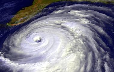
Hurricane Francis heading towards Florida – An Act of God or Guided by Man?
 The
BibleSearchers Reflections
The
BibleSearchers Reflections
Reflections on the Time of the End
By Robert Mock MD
Gleanings on Global News at the
Time of the End
October-November, 2004 Special Edition Issue
Topics
As the student of prophecy watches this world careening towards its destiny in the near apocalyptic future, we must consider what is happening to the signs in the heavens and the catastrophes on earth. As Yahshua (Jesus) was sitting on the side of the Mount of Olives just before His crucifixion, He outlines to His Jewish disciples in sequence what will happen before the time of the end. In Matthew 24:1-14, we find this sequence of events. Since His followers were authentic orthodox Jewish believers, He is speaking to what will be happening to the Jewish people and the gentiles who were followers of the God of Israel.
- Deceptions in the name of Christ
- Wars and rumors of wars – “the end is not yet.”
- Nations will rise against nations
- There will be famines
- There will be earthquakes in various places – “this is the beginning of birth pangs.”
- You will be persecuted and put to death
- You will be hated by all nations because of me.
- Many will turn away from the faith and will betray and hate each other
- False prophets will appear and deceive many.
- Increase of wickedness, the love of most will grow cold – Laodicean Church
- This gospel of the kingdom shall be preached in all the world, and then the end will come.
Consider the fact that famines, earthquakes with the associated volcanic activities are related to the beginning of the birth pangs. It might be well to review what is happening to God’s creation when the Eternal One of Israel is preparing this earth for the coming era reign of His son, the Moschiach of Israel.
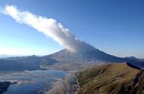
Volcanos
Mount St. Helens' Crater Floor Rising – October 7, 2004
Mount St.
Helens, Washington - Part of Mount St. Helens' crater floor has risen 50 to 100 feet since
Tuesday while earthquake rates have been low, signs that magma is moving
upward without much resistance, scientists said Thursday.
"The skids are greased," Jake Lowenstern, a U.S. Geological Survey volcanologist, said at a news conference at the Cascades Volcano Observatory in Vancouver, Wash.
With the latest rising, an area of the crater
floor just south of the nearly 1,000-foot lava dome has risen about 250 feet
since the mountain began stirring two weeks ago, Lowenstern said. There's no
way to tell when magma might reach the surface, he said. On Wednesday,
scientists lowered the alert level for the southwest Washington volcano, saying
earthquake activity was down to the 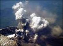 lowest
level since before the mountain started venting steam last week.
lowest
level since before the mountain started venting steam last week.
U.S. Geological Survey scientists downgraded the "volcano alert" to a "volcano advisory," indicating the probability of an eruption that could endanger lives and property had decreased significantly since Saturday, when thousands of people were evacuated from the mountain. Despite the new detail Thursday on the magma movement, scientists said there was no reason to raise the alert level back up. Larry Mastin, a USGS expert in the physics of volcano eruptions, said that while there's an outside chance an eruption could send a plume of ash 15 miles into the air or higher, there is no indication that any eruption is imminent or that it would threaten lives or property.
Earthquake activity remained relatively low Thursday, with about one magnitude 1 quake a minute. The volcano was occasionally venting steam as water trickled down and hit hot rocks, Lowenstern said.
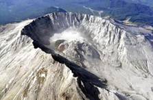
Scientists planned to make another flight over the volcano's crater Thursday to sample gas emissions and take thermal images, and to continue preparing instruments on the mountain for the winter. A brief break in the clouds late Wednesday gave visitors a peek at weak steam emissions in the volcano's crater.
On Tuesday, under sunny skies, a spectacular cloud of steam and old ash rose thousands of feet above the 8,364-foot peak and a light dusting of gritty ash fell on some areas northeast of the mountain. It was the largest of a series of emissions of steam and ash since Friday. Geologists continued to emphasize that there is little chance of anything similar to the blast that blew 1,300 feet off the top of the peak in May 1980, killing 57 people and paralyzing much of the inland Pacific Northwest with gritty volcanic ash. Before then, Mount St. Helens had been silent since the 19th century. The U.S. Forest Service reiterated Thursday that closures around the volcano — including the Johnston Ridge observatory five miles north of the crater — would remain in effect until authorities determine the area is safe. (Article)
Mexico's 'Fire Volcano' Erupts, No Evacuations Yet – October 1, 2004
La Yerbabuena, Mexico - Mexico's so-called "Fire Volcano" spewed lava, glowing rocks and flames on Friday in an eruption that authorities said was not yet serious enough to evacuate nearby villages. A wide stream of lava had been clearly visible at night flowing down the 12,540-foot (3,860-meter) volcano in Colima state. A giant column of smoke billowed several miles into the air during the day, an eyewitness said. The "Fire Volcano" is located in a sparsely populated rural zone between the western, coastal states of Colima and Jalisco, about 300 miles from Mexico City. Emergency authorities said the explosions have continued since activity started with small blasts on Wednesday, but that the situation was still not serious enough to move the roughly 100 residents of the tiny villages around it.
"The explosions are continuing and a lot of material is coming out, but we do not yet consider it a risk situation," Colima's chief of civil protection, Melchor Urzua, said. Experts say the activity has been caused by pressure building under a dome that covers Colima's crater. Smoke and gas are now spewing from a crack in the dome. In a statement, Colima's Volcano Observatory said it hoped the lava flows would continue, relieving pressure inside the cone-shaped mountain. Villagers were last evacuated in May 2002, after a series of small eruptions. The last major explosion of the Volcano of Fire was in 1913, but it has erupted intermittently in the last decade. (Reporting by Bernardo de Niz in La Yerbabuena and Frank Jack Daniel and Miguel Angel Gutierrez in Mexico City)
Japanese volcano erupts again - September 25, 2004
 TOKYO - A Japanese volcano which burst
into life earlier this month with its biggest eruption in 21 years, erupted again,
the Meteorological Agency said. An eruption, measuring three on a scale of zero
to five, was observed at 7:44 pm (1044 GMT) from the 2,568-meter (8,474-foot)
high Mount Asama, the agency said.
TOKYO - A Japanese volcano which burst
into life earlier this month with its biggest eruption in 21 years, erupted again,
the Meteorological Agency said. An eruption, measuring three on a scale of zero
to five, was observed at 7:44 pm (1044 GMT) from the 2,568-meter (8,474-foot)
high Mount Asama, the agency said.
The agency said tremors related to the mid-scale eruption continued, urging local residents to monitor volcano activity on the mountain which lies some 150 kilometers (95 miles) northwest of Tokyo. But local authorities did not issue an evacuation warning and there were no reports of injuries. "We observed some sticky rain containing volcanic ashes but there was no real damage from the latest eruption," a local police official said. Mount Asama last went up on September 1, the volcano's most violent activity since April 1983. The eruption threw rocks over a wide area and caused a forest fire. Prior to this month, Mt Asama last erupted in April last year.
Japan volcano erupts for second time – September 14, 2004
Tokyo, Japan (Reuters) - A volcano in central Japan has spewed smoke high into the sky in its second eruption in less than a day, but officials say the scale does not appear to be large. Mount Asama, a 2,568 metre peak 87 miles northwest of Tokyo, sent greyish smoke about 1,000 metres into the sky around 3:30 p.m. (7.30 a.m. British time), an official at Japan's Meteorological Agency said. The volcano, one of Japan's more active, had spewed smoke 300 metres high for several minutes before dawn…."More eruptions could well lie ahead, but there are no signs of any noticeable changes in the mountain that could signal a substantial eruption."
Mount Asama has had several other minor eruptions in recent years, including at least four in 2003. Japan, located in the so-called Ring of Fire, an arc of volcanoes and oceanic trenches partly encircling the Pacific Basin, has 108 active volcanoes -- 10 percent of all in the world. (Article)
Volcano bubbles in Philippines – September 13, 2004
 phschool - Mayon volcano in the Philippines showed new signs of
life this week. The volcano spat out hot volcanic material that touched off
grass fires along its slopes. Volcanologists say magma is rising within its
crater. But they don't think the pressure is great enough at this time to
trigger a full-scale eruption. Still, people were warned to stay out of the
six-kilometer (four-mile) danger zone around the crater.
phschool - Mayon volcano in the Philippines showed new signs of
life this week. The volcano spat out hot volcanic material that touched off
grass fires along its slopes. Volcanologists say magma is rising within its
crater. But they don't think the pressure is great enough at this time to
trigger a full-scale eruption. Still, people were warned to stay out of the
six-kilometer (four-mile) danger zone around the crater.
Mayon is located about 200 miles (320 kilometers) south of Manila. It is considered the most dangerous of the 22 active volcanoes in the Philippines. In 2001, the volcano erupted several times and forced about 50,000 people to evacuate their homes. Mayon had a few small eruptions in 2003 as well.
At least twelve of its eruptions have been killers. In 1993, a fiery pyroclastic flow killed 68 people and chased 60,000 others from their homes. Mayon's most violent eruptions were in 1814, when 1,200 people were killed and a village was buried in volcanic mud, and in 1911, when 1,000 people died. Many volcanoes occur at plate boundaries where one plate sudducts or dives under another. Crust from the sinking plate melts and forms magma which then rises to the surface inside the volcano. The Philippines are found along the Philippine Trench, where the Philippine plate plunges beneath the Eurasian plate. (Article)
 Scientists
Say Mauna Loa May Soon Erupt – September 13, 2004
Scientists
Say Mauna Loa May Soon Erupt – September 13, 2004
![]() Kailua-Kona, Hawaii (Rednova) -- Earthquakes have
been rumbling more frequently deep beneath Mauna Loa, suggesting that the
world's largest volcano is getting ready to erupt for the first time in 20
years, scientists said.
Kailua-Kona, Hawaii (Rednova) -- Earthquakes have
been rumbling more frequently deep beneath Mauna Loa, suggesting that the
world's largest volcano is getting ready to erupt for the first time in 20
years, scientists said.
Mauna Loa volcano. Image credit: NASA - click to enlarge.
"We don't believe an eruption is right around the corner, but every day that goes by is one day closer to that event," said Paul Okubo, a seismologist at the Hawaiian Volcano Observatory on the Big Island. Mauna Loa erupted for three weeks in 1984, sending a 16-mile lava flow toward Hilo. Since then, the U.S. Geological Survey estimates that more than $2.3 billion has been invested in new construction along Mauna Loa's slopes. Since July, more than 350 earthquakes have been recorded far beneath the 13,677-foot-high Mauna Loa, said Don Swanson, scientist-in-charge at the observatory." Mauna Loa is grumbling, growling and getting ready to come out of its den," he told West Hawaii Today for Sunday's editions. The earthquakes have been what seismologists call "long period," which means their signals gradually rise above the noise generated by usual seismic activity. "Such a concentrated number of deep, long-period earthquakes from this part of Mauna Loa is unprecedented, at least in our modern earthquake catalog dating back to the 1960s," Okubo said. Mauna Loa is within Hawaii Volcanoes National Park, which also contains the well-known Kilauea volcano. Kilauea has been erupting continuously since Jan. 3, 1983.
Mauna Loa – Earth’s Largest Volcano
Photograph by J.D. Griggs on January 10, 1985
Rising gradually to more than 4 km above sea level, Mauna Loa is the largest volcano on our planet. Its long submarine flanks descend to the sea floor an additional 5 km, and the sea floor in turn is depressed by Mauna Loa's great mass another 8 km. This makes the volcano's summit about 17 km (56,000 ft) above its base! The enormous volcano covers half of the Island of Hawai`i and by itself amounts to about 85 percent of all the other Hawaiian Islands combined.
Mauna Loa is among Earth's most active volcanoes, having erupted 33 times since its first well-documented historical eruption in 1843. Its most recent eruption was in 1984. Mauna Loa is certain to erupt again, and we carefully monitor the volcano for signs of unrest. See current activity for a summary of our monitoring efforts.
No Sign Yet of Predicted Big California Earthquake – September 6, 2004
Los Angeles (Planetark) - The clock is running out on a highly publicized prediction that a major earthquake will rip through Southern California by Sunday. But even if the earth does not move by the weekend, seismologists largely agree that the forecast had done more good than harm by reviving interest in the controversial science of quake prediction.
A UCLA team startled Californians and the wider scientific world in January by predicting there was 50-50 chance of a 6.4 magnitude or larger quake hitting a 12,000 square mile mostly desert area east of Los Angeles by Sept. 5. They used an algorithm, or mathematical pattern recognition formula, developed by team member Professor Vladimir Keilis-Borok which had already successfully forecast a 6.5 temblor in central California in December 2003 and the 8.1 magnitude quake that struck the Japanese island of Hokkaido in September last year.
The public forecast of a quake in southern California shook up the world of seismology where reliable earthquake prediction was largely discredited after the 1980s when another big prediction embarrassingly fell flat. But a panel of earthquake experts deemed the prediction valid although too untested to warrant emergency measures in a state which measures up to 60 earthquakes a day - few of them even rattling a window. As one seismologist said, "Even if he was right, what can you do in a six-month window? You are far more likely to be murdered in L.A. than die in an earthquake in California." (Entire Article)
The Big One – The Next Big California Earthquake - Book by George Pararas-Carayannis, Ph.D.
Earthquake Swarm Shakes Eastern Sierra - September 25, 2004
 Mammoth Lakes, Calif (Wjla). - A swarm of earthquakes — one a magnitude-5.5 — jolted a
remote, sparsely populated area along the eastern Sierra Nevada on Saturday,
authorities said. A Mono County sheriff's dispatcher said there were no
immediate reports of any injuries or damage from the temblors centered along
the California-Nevada line about 30 miles northeast of Mammoth Lakes. David Oppenheimer, a seismologist for the U.S. Geological Survey in Menlo Park, said
most of the 70 quakes in the sequence that began 12:02 a.m. Saturday were
magnitude-2 or less. The magnitude-5.5 temblor that struck at 4:02 p.m. was
followed by a magnitude-5.4 quake at 4:43 p.m., he said. The moderate quakes
were the biggest in the swarm and the biggest on the fault in more than a
decade. (Article)
Mammoth Lakes, Calif (Wjla). - A swarm of earthquakes — one a magnitude-5.5 — jolted a
remote, sparsely populated area along the eastern Sierra Nevada on Saturday,
authorities said. A Mono County sheriff's dispatcher said there were no
immediate reports of any injuries or damage from the temblors centered along
the California-Nevada line about 30 miles northeast of Mammoth Lakes. David Oppenheimer, a seismologist for the U.S. Geological Survey in Menlo Park, said
most of the 70 quakes in the sequence that began 12:02 a.m. Saturday were
magnitude-2 or less. The magnitude-5.5 temblor that struck at 4:02 p.m. was
followed by a magnitude-5.4 quake at 4:43 p.m., he said. The moderate quakes
were the biggest in the swarm and the biggest on the fault in more than a
decade. (Article)
Quake Strikes Central California – September 29, 2004
Parkfield (Fox News) - A strong earthquake shook the state Tuesday from Los Angeles to San Francisco, cracking pipes, breaking bottles of wine and knocking pictures from walls. There were no immediate reports of any injuries from the 6.0-magnitude quake and its more than 160 aftershocks. The quake was centered about seven miles southeast of Parkfield, a town of 37 people known as California's earthquake capital. The town is one of the world's most seismically active areas, located on the San Andreas Fault. "Things were shaking so bad you couldn't tell where to go next," said Parkfield Vineyard owner Harry Miller, who grows 170 acres of wine grapes. "Trees shaking like brooms, and dust coming from everywhere."…
Parkfield was shaken by six similar 6.0 earthquakes between 1857 and 1966. Countless smaller tremors constantly rattle the area, which is covered with just about every type of tool used to study quakes as part of a long-term research project. "This will probably be the most well-recorded earthquake in history," said Michael Blanpied of the USGS. The area is 21 miles northeast of Paso Robles, scene of an earthquake that killed two people in December. That quake pitched an 1892 clock tower building onto the street and crushed a row of parked cars. It was the state's first deadly quake since the 6.7-magnitude one that hit the Northridge area of Los Angeles in 1994… (Article)
Two Earthquakes Rattle Central California - October 10, 2004
Paso Robles (ABC News) – Two earthquakes struck early Saturday in the same part of California that was rocked by a powerful temblor earlier in the week. The largest, a 4.0-magnitude quake, hit at 5:22 a.m. 10 miles southwest of Paso Robles. It followed a 3.2-magnitude quake that struck at 12:04 a.m. 22 miles northeast of Paso Robles. San Luis Obispo County fire officials said they had received no reports of damage or injuries. Paso Robles is about 25 miles southwest of Parkfield, where Tuesday's 6.0-magnitude quake was centered. That quake damaged some homes and a winery but did not cause any injuries. Parkfield, known as the earthquake capital of California, has been a focus of geologists for years because it sits on the San Andreas fault and has had regular earthquake activity for a century. Saturday's earthquakes were among hundreds of temblors to hit the area since Tuesday. (Article)
Quake Measuring 6.1 Hits Aleutian Islands - September 25, 2004
Anchorage, Alaska - A powerful earthquake shook the Aleutian Islands on Sunday, but there were no reports of damage on the sparsely populated island chain. The magnitude-6.1 quake hit just before 12:30 p.m., said Coast Guard Petty Officer Jamal Daniels, at the Coast Guard's long range navigation station on Attu. "You could hear it before you could feel it," Daniels said. "It was kind of like a pounding sound, like somebody was pounding on the wall with both of their fists. The mirror started shaking, and the ground started rolling." The 20 people at the Coast Guard station are the only inhabitants of Attu, Alaska's westernmost point more than 1,500 miles southwest of Anchorage. The temblor, which was centered 90 miles south of Attu in the Pacific Ocean, did not generate a tsunami, according to the West Coast Alaska Tsunami Warning Center. An earthquake of that size could cause significant damage if it were to strike in an urban area. Michael Burgy, a technician at the warning center, said the quake also was felt strongly on nearby Shemya Island, where about 24 Air Force members work.
Large earthquake shakes Manila - October 8, 2004
Manila, Philippines (MSNBC) - An earthquake with a magnitude of 6.4 shook Manila on Friday night, swaying high rises, knocking out power over a wide area and sending frightened residents into the streets. There were no immediate reports of injuries or damage. The shaking began at 10:36 p.m. and lasted for more than a minute. The epicenter of the quake was on Mindoro island, 55 miles south-southwest of Manila. The temblor was felt over a wide area, including nearly 90 miles north of the sprawling capital on the main Philippine island of Luzon. The U.S. Geological Survey in Colorado said on its Web site the magnitude was 6.4 at a depth of about 73 miles…
‘Ring of Fire’
risks
The Philippines is
along the Pacific Ring of Fire, where earthquakes and volcanic activity are
common. A magnitude 6.2 quake shook Manila and surrounding areas of Luzon three weeks ago. The Institute of Vulcanology and Seismology said Friday’s quake was
believed to be in the same fault line, along the Manila Trench. Solidum said
that raised concerns that the area is becoming active. “It means that part is
moving. We could have more earthquakes, so we should always be careful,”
Solidum said…
A magnitude 7.7 earthquake in 1990 killed nearly 2,000 people on Luzon. (Article)
Strong quake rattles Taiwan – October 15, 2004 – Home of the earth’s tallest building
Taipei, Taiwan (CNN) -- A large earthquake centered
off Taiwan's eastern coast shook buildings in the capital of Taipei, damaging
buildings and injuring several people, officials said. The U.S. Geological
Survey (USGS) reported the quake, which struck after noon local time (0400 GMT)
on Friday as measuring 6.7 in magnitude while Taiwan's Central Weather
Bureau put the tremblor at 7.0. The weather bureau said  the temblor was the strongest
to hit the island since a 7.6-magnitude earthquake hit central Taiwan in 1999, causing more than 2,300 deaths.
the temblor was the strongest
to hit the island since a 7.6-magnitude earthquake hit central Taiwan in 1999, causing more than 2,300 deaths.
Taipai 10 – the World’s Tallest Building
The quake rocked buildings for about one minute in the capital Taipei. On the city's streets, the quake caused sidewalks to go up and down slightly. "It was very scary. I wanted to run but didn't know where to go," an old man, who was in a restaurant in the world's tallest building, the 508-metre (1,667-foot) Taipei 101, said on television. "It felt just like the one in 1999," said the man who was visiting Taipei from the central mountainous county of Nantao, the epicentre of the earthquake five years ago. The government's Disaster Recovery Centre said the quake damaged some houses and injured a few people, but there were no major damage or casualties, according to Reuters. The quake's epicenter was off Taiwan's eastern shore -- about 125 kilometers (77 miles) east-southeast of Taiwan's capital city, Taipei, according to the USGS. Taking into account the distance from the capital city, Taiwan's Central Weather Bureau said Taipei would have experienced a magnitude of 4.0 which is classified as a light earthquake. Since October 7, Taiwan has been hit by four earthquakes of magnitude 4.4 and above.Earthquakes frequently hit Taiwan but usually cause little or no damage. (Article)
Powerful
quakes rock Japan; at least 900 hurt – October 24, 2004
![]() Ojiya, Japan (Albany
Democrat-Herald) — A series of powerful earthquakes and aftershocks struck
northern Japan on Saturday, killing at least 16 people and reportedly injuring
more than 900 as buildings crumbled, a bullet train derailed and roadways
were torn apart. At least four people were missing Saturday night, the
government said. Throughout the region, electric, gas and telephone services
were knocked out and water and sewage mains burst.
Ojiya, Japan (Albany
Democrat-Herald) — A series of powerful earthquakes and aftershocks struck
northern Japan on Saturday, killing at least 16 people and reportedly injuring
more than 900 as buildings crumbled, a bullet train derailed and roadways
were torn apart. At least four people were missing Saturday night, the
government said. Throughout the region, electric, gas and telephone services
were knocked out and water and sewage mains burst.
The quakes — the most powerful recorded as magnitude 6.8 — were spread over several hours and centered on Ojiya, about 160 miles northwest of Tokyo. Still, buildings swayed in the Japanese capital. "I've never felt anything like it before,'' said Yoichi Kato, the owner of a 7-11 store in Kashiwazaki, about 12 miles west of the epicenter. "It was so strong, I was too surprised to be scared.'' The quake knocked bottles and food off the convenience store's shelves, but otherwise caused his shop limited damage, Kato said. The first quake hit at 5:56 p.m. and was centered about 12 miles beneath the surface, the Meteorological Agency said. At least six more tremors hit over the following hours, including quakes of magnitude 6.2 and 5.9, the agency said…
Teams were dispatched to assess damage and aid residents but darkness and buckled roads hampered their efforts, officials said. Eleven military helicopters fanned out to check the damage and help with rescue operations, the agency said. The quakes were centered in relatively rural areas. The government has estimated that some 7,000 people would die if such a powerful quake hit the Tokyo area… (Full Article)
Thin Glaciers Get Thinner in Antarctica - Report - September 25, 2004
Washington DC – (Planetark) Some of Antarctica's glaciers are melting faster than snow can replace them, enough to raise sea levels measurably, scientists reported on Friday. Measurements of glaciers flowing into the Amundsen Sea, on the Pacific Ocean side of Antarctica, show they are melting much faster than in recent years and could break up. And they contain more ice than was previously estimated, meaning they could raise sea level by more than predicted, the international team of researchers writes in the journal Science. "The ... Amundsen Sea glaciers contain enough ice to raise sea level by 1.3 meters (4 feet)," the researchers wrote in their report. "Our measurements show them collectively to be 60 percent out of balance, sufficient to raise sea level by 0.24 mm (nearly 0.01 inch) per year," they added.
And as the surrounding ice shelves melt -- which they are doing -- this process will speed up, the researchers said. "The ice shelves act like a cork and slow down the flow of the glacier," said Bob Thomas of the NASA Goddard Space Flight Center's Wallops Flight Facility in Virginia. Theirs is the second report this week to warn of rapidly melting glaciers in Antarctica. On Tuesday a team at NASA and the University of Colorado reported that the 2002 breakup of the Larsen B ice shelf on the other side of the continent had accelerated the breakup of glaciers into the Weddell Sea. Many teams of researchers are keeping a close eye on parts of Antarctica that are steadily melting.
Ice Shelves
Large ice shelves in the Antarctic Peninsula disintegrated in 1995 and 2002 as a result of climate warming. But these floating ice shelves did not affect sea level as they melted. Glaciers, however, are another story. They rest on land and when they slide off into the water they instantly affect sea level. "The rates of glacier change remain relatively small at present," said Eric Rignot of NASA's Jet Propulsion Laboratory in Pasadena, California, who worked on Friday's study. "But the potential exists for these glaciers to increase global sea level by more than one meter (3 feet). The time scale over which this will take place depends on how much faster the glaciers can flow, which we do not know at present." The measurements also show the glaciers are thicker than once believed. This means more melting and more rapid melting, Thomas said.
"Our measurements show an increase in glacier thinning rates that affects not only the mouth of the glacier, but also 60 miles to 190 miles inland," Thomas said in a statement. The researchers from NASA, the Centro de Estudios Cientificos in Chile, the University of Kansas and Ohio State University wrote their estimates based on satellite data and measurements from a Chilean P-3 aircraft equipped with NASA sensors. Experts say that overall sea levels around the world are going up by about 1.8 mm or 0.07 inch a year. About half of this comes from melting ice in glaciers. The melting into the Amundsen sea is now more than the previous amount from all of Antarctica and more than the estimated contribution from Greenland, the researchers said. (Article)
Arctic's toxic
burden harms bears – September 13, 2004 -  Evidence that the health of polar bears is being damaged by chemicals
has been reinforced by new Arctic research.
Evidence that the health of polar bears is being damaged by chemicals
has been reinforced by new Arctic research.
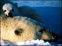
Svalbard has as many bears as people (Image: Svein B Oppegaard)
British Broadcasting News - The findings show biological changes in the hormone and immune systems of the bears are related to the levels of toxic contaminants in their bodies. WWF, the global conservation campaign, says the data confirms the findings of other research in the last four years. It says the chemicals may affect the bears' behaviour and breeding, and make them more vulnerable to infection. The research is published in two academic journals: the Journal of Toxicology and Environmental Health, and Environmental Health Perspectives. It was conducted by international teams of scientists in Canada and on Spitzbergen, the main island of the Svalbard archipelago in the high Arctic.
WWF is publicising the findings to support its campaign for more stringent laws to control chemicals. The substances blamed for the damage are PCBs (polychlorinated biphenyls) and pesticides: the higher their level in the bears, the lower the level of antibodies found in their blood. WWF says: "Toxic chemicals were also correlated with the steroid hormone cortisol and thyroid hormone levels in Svalbard polar bears. "Reduced levels of antibodies leave bears more susceptible to infection. Altered hormone levels could result in a wide range of negative health impacts, such as development, behaviour, and reproductive problems."
Unable to cope
The bears' breeding may be affected (Image: Svein B Oppegaard)
Dr Andrew Derocher, who has long experience in studying the bears' contamination, said: "The studies conducted on polar bears over the last few years all conclude that these animals are negatively affected by chemical pollution.
"Most polar bears probably have several hundred man-made chemicals in their bodies and they have never evolved mechanisms to deal with them.
"The unintentional tinkering with the hormone and immune system of a polar bear is unlikely to be good for them."
WWF
says that although the contaminants found in these studies are no longer widely
used, they are slow to break down in the environment and can 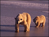 remain in water, ice,
and soil for many years. Brettania Walker of WWF's Arctic programme said:
"Other contaminants, with similar properties, continue to be used on a
day-to-day basis in manufacturing processes and products throughout the world.
remain in water, ice,
and soil for many years. Brettania Walker of WWF's Arctic programme said:
"Other contaminants, with similar properties, continue to be used on a
day-to-day basis in manufacturing processes and products throughout the world.
Mother and cub in Canada (Image: Francois Pierrel)
In 2000 scientists on Svalbard said more than 1% of the islands' bears were hermaphroditic, showing the reproductive organs of both sexes. PCBs were manufactured for use in electrical equipment, and although many countries have now banned them, there is a reservoir of the chemicals that has escaped into the environment.
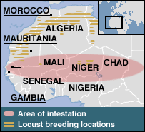
. Locusts
invade Mauritania capital – October 3, 2004
Locusts
invade Mauritania capital – October 3, 2004
Locusts have wiped out harvests in part of Mauritania
British Broadcasting News - A giant swarm of locusts has invaded the capital of Mauritania, Nouakchott, in north-western Africa.
The United Nations Food and Agriculture Organisation has warned that the locust plague is still in its early stages and is set to worsen in the coming weeks. Locusts have already ravaged much of Mauritania's crops and pasture land.
The air crackles with the flutter of their wings and trees rustle with their incessant munching. "We are fed up with these locusts", said one Mauritanian. "We haven't got much greenery and they eat it all."
Upturned buckets
 Swarms of locusts have
descended on the Mauritanian capital three times in recent months, filling the
sky, shredding leaves and bombarding inhabitants. On the streets of Nouakchott children swing sticks like baseball bats, striking out the locusts. Others,
forced to go outside have taken to wearing upturned buckets on their heads to
protect themselves from the clawed insects which like to settle in hair and on
shoulders.
Swarms of locusts have
descended on the Mauritanian capital three times in recent months, filling the
sky, shredding leaves and bombarding inhabitants. On the streets of Nouakchott children swing sticks like baseball bats, striking out the locusts. Others,
forced to go outside have taken to wearing upturned buckets on their heads to
protect themselves from the clawed insects which like to settle in hair and on
shoulders.
For the city dwellers, the locusts are a nuisance, but for 80% of Mauritanians, who make their living from farming or livestock, the current plague is an act of God. In the south, many Mauritanians have seen their entire harvest wiped out in a number of hours.
And this is just the beginning. The UN's Food and Agriculture Organisation told the BBC a new generation of locusts is maturing and taking to the skies, bringing the risk of famine ever closer.
Locusts Encroach on West African Rice-Growing Area – September 24, 2004
Bamko (Reuters) - West Africa's worst locust plague for 15 years has encroached on one of the region's largest rice-growing areas, authorities in Mali said on Friday. Massive swarms have infested thousands of km (miles) of land from the Atlantic coast to landlocked Chad in the last two months, already causing substantial damage to grain crops. Officials in Mali said they had taken steps such as digging trenches to protect the Office du Niger, a large area of irrigated land developed under French colonial rule, from so-called hopper bands of young locusts that cannot yet fly. But swarms of the older flying locusts have arrived this week at the edge of the area in Southern Mali, which covers 65,000 hectares (160,000 acres) and provides some 400,000 tons of paddy rice -- around half the country's annual rice needs.
 "The Office du
Niger has been the subject of special attention in the fight against the
locusts, we put a protective ring around the zone to counter the hopper
bands," said Agriculture Ministry official Yaya Diarra. "But these
were measures on the ground and we were talking mainly about the hopper bands.
Since Sunday, we've been alerted to the arrival of swarms in ... communities on
the edge of the area near Mauritania," he said. Diarra said the locusts
had destroyed about 15 to 20 percent of crops in the areas on the fringe of the
rice-growing zone and authorities had sent an extra plane to spray pesticides,
boosting the efforts of one aircraft already there.
"The Office du
Niger has been the subject of special attention in the fight against the
locusts, we put a protective ring around the zone to counter the hopper
bands," said Agriculture Ministry official Yaya Diarra. "But these
were measures on the ground and we were talking mainly about the hopper bands.
Since Sunday, we've been alerted to the arrival of swarms in ... communities on
the edge of the area near Mauritania," he said. Diarra said the locusts
had destroyed about 15 to 20 percent of crops in the areas on the fringe of the
rice-growing zone and authorities had sent an extra plane to spray pesticides,
boosting the efforts of one aircraft already there.
Regional agriculture experts meeting this month in Senegal's capital Dakar said West Africa may lose up to a quarter of a bumper grain harvest this year if the plague is not brought under control but famine did not appear to be a danger for now. West Africa's impoverished nations lack the money, equipment and chemicals to control the plague and have appealed to rich countries for help. Some diplomats say both governments and aid agencies have been too slow in responding to the crisis. Mali's Agriculture Minister Seydou Traore said last week the locusts had infested a swathe of the country producing nearly 1.5 million tons of cereal -- between 40 and 45 percent of the annual cereal harvest.
Groups of young locusts were also chomping undergrowth and stripping shrubs of leaves this week near a nature reserve outside the Senegalese town of Saint Louis, by the Atlantic. Some 3,500 km (2,200 miles) away in Chad's capital N'Djamena, the same type of young yellowy-green locusts infested buses and hotel grounds on Friday, flitting around lamps and hopping onto diners' plates. (Article)
Jeanne could be year's costliest – September 27, 2004
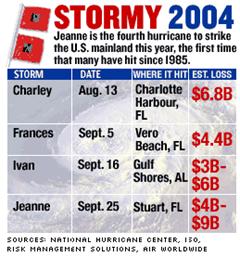 NEW YORK (CNN/Money) - Hurricane Jeanne
could end up being the most expensive storm to hit the United States in a year of very expensive storms.
NEW YORK (CNN/Money) - Hurricane Jeanne
could end up being the most expensive storm to hit the United States in a year of very expensive storms.
In addition to the effect on millions of homeowners, Jeanne, like the earlier storms, has affected two of Florida's biggest industries -- orange growers and tourism.
Risk Management Solutions, a catastrophe modeling firm that works for the insurance industry, estimated Sunday that Jeanne could cause $4 billion to $8 billion in insured losses, while rival firm AIR Worldwide put the forecast a bit higher, at $5 billion to $9 billion. A loss at the upper end of those ranges would be second only to Hurricane Andrew, which in 1992 caused $20 billion in insured losses, adjusted for inflation. Just before midnight Saturday, Jeanne slammed into Stuart, Fla., about 10 miles from where Frances hit Labor Day weekend, killing six and tracking a path remarkably similar to Frances. Jeanne also crossed the path of Hurricane Charley, which hit the state Aug. 13.
Jeanne had sustained winds of 120 mph. But by Monday morning it had weakened to tropical storm status and was expected to be downgraded to a tropical depression later in the day. Jeanne's path being so similar to that of Frances, and just three weeks later, is adding to estimated losses, RMS meteorologist Kyle Beatty said. Many buildings damaged by Frances have not been completely repaired and so are susceptible to further damage, he added. "If a roof hasn't been fully fixed, there's greater risk of water damage," he said. In addition, Beatty said some insurers were allowing customers hit by both Frances and Hurricane Charley to count the losses as a single event, not forcing them to pay two separate deductibles, which in many cases range from 2 to 5 percent of a home's insured value. A similar policy for Jeanne would increase insured losses, he said. Another factor driving up losses could be the shortage of contractors and some supplies needed to make repairs.
Leading businesses hit
Many of the state's largest industries, including oranges
and tourism, took
another hit from Jeanne after reeling from two of the previous storms. Orange
juice futures jumped the 5-cent limit for nearby contracts on commodities
exchanges, said 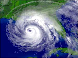 Jason
Roose, analyst for US Commodities Inc. in West Des Moines, Iowa.
Jason
Roose, analyst for US Commodities Inc. in West Des Moines, Iowa.
That pushed the November contract to 83.75 cents a pound, leaving prices overall up nearly 20 percent since July, before the current round of storms started. "There continues to be substantial damage in production of orange juice," Roose said. "We don't know the extent, but we know it can take two or three years to replace a tree damaged or destroyed in a hurricane…"
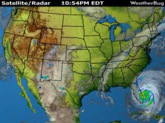
Hurricane Ivan Aiming at the Panhandle of Florida
Meanwhile, tourism has also been hurt by the storms. Disney World in Orlando closed early Saturday and remained closed Sunday, the third hurricane-related closing of the season. That's the worst storm-related disruption since the theme park opened in 1971…"There is a recognition that hurricanes generally don't happen once you get past the end of November," he said.
Even if Jeanne's insured losses are at the low end of estimates, it is to be either the fifth or sixth most expensive storm in U.S. history. There are still no specific damage estimates available for Hurricane Ivan. And total insured losses -- now estimated at $18 billion to $26 billion -- will make this among the most expensive years for insurers. This is the first year since 1985 in which four storms make it to the U.S. mainland at hurricane strength…
Chaos spreads in flood-stricken Haiti, Death toll reportedly tops 1,500 – September 25, 2004
Gonaives, Haiti (AP) -- A boy was hit by a truck
and killed as crowds of hungry flood victims pressed up against the gates of a
warehouse storing food aid Saturday, and U.N. peacekeepers sent reinforcements
to try to keep order amid growing chaos in this flood-stricken city. The death toll shot
up to an estimated 1,500 a week after the floods, while many more remained
missing. The boy was hit by a truck that had just dropped off an aid
shipment and was 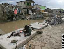 attempting to drive out of the fenced compound as a crowd pushed
in around the open gate, said Roseline Corvil, an official of the aid agency
CARE International. "I presume that he did not see the child," she
said.
attempting to drive out of the fenced compound as a crowd pushed
in around the open gate, said Roseline Corvil, an official of the aid agency
CARE International. "I presume that he did not see the child," she
said.
A man stays with his belongings on the street in front of his house in Gonaives
Some in the crowd said the boy was 13. His body was left lying on the road until his family could arrive. Homeless people waded through other newly flooded streets following an overnight thunderstorm that drenched the northwestern city of Gonaives it was starting to dry out.
Interim Prime Minister Gerard Latortue and other officials were drawing up plans to temporarily move thousands of flood victims into tents to allow a cleanup of neighborhoods coated with contaminated sludge and debris, said Paul Magloire, an adviser. Latortue estimated more than 1,500 were killed in the floods unleashed last weekend by Tropical Storm Jeanne, Magloire said. The final toll could be much higher. Dieufort Deslorges, a spokesman for Haiti's civil protection agency, said it had recorded 1,286 dead and 1,129 missing. Officials said they expect to find hundreds of bodies in mud and collapsed homes. Officials say most of the missing can be presumed dead -- washed out to sea or buried in storm debris…
An estimated 300,000 Haitians were left homeless, most in Gonaives, and people have been mobbing aid trucks and looting relief supplies. Gang members have been trying to steal food out of the hands of aid recipients, and U.N. peacekeepers -- who already numbered about 600 in Gonaives -- were sending in 140 Uruguayan troops as reinforcements to try to keep order, said Toussaint Kongo-Doudou, a spokesman for the U.N. mission... Stacks of bodies had disappeared by Saturday outside Gonaives' General Hospital. Many bodies -- though officials disagreed over how many -- were buried in a mass grave. (Sad and Sobering Article)
Why so many hurricanes? – September 13, 2004 - This summer's onslaught repeats a long-term cycle, bringing back warmer waters and more storms.
Christian Science Monitor - Forecasters sensed the 2004 hurricane season would be very active, but even storm veterans have been surprised by the past 30 days. Last month marked the first time since the beginning of postwar hurricane reconnaissance flights that August generated three major hurricanes in the Atlantic. If the current forecast track for hurricane Ivan holds, it will be the third hurricane to strike Florida in a month.
 Yet for all its fury, this season's burst of
activity falls well within the bounds of past experience. What's surprising,
say experts, is that the US and Florida haven't seen more major storms make
landfall over the past few decades.
Yet for all its fury, this season's burst of
activity falls well within the bounds of past experience. What's surprising,
say experts, is that the US and Florida haven't seen more major storms make
landfall over the past few decades.
Despite the damage wrought by Charley and Frances, "we've been very fortunate," says William Gray, a tropical-meteorology specialist at Colorado State University who pioneered seasonal hurricane forecasting. He notes that since 1995, only 1 out of 7 major hurricanes spawned in the Atlantic have made landfall in the US, compared with the 100-year average of 1 in 3. The Florida peninsula alone saw 14 major hurricanes between 1926 and 1965. Since 1966, only three major storms have struck - Andrew, Charley, and Frances. (And now Ivan and Jeanne ed.)
Now forecasters have their eyes on Ivan, which has devastated Grenada and Jamaica and at press time was bearing down on the Cayman Islands and Cuba with sustained winds near 155 miles an hour. Ivan has been blamed for 56 deaths in the Caribbean basin and, according to Red Cross estimates, 60,000 people on Grenada - two-thirds of the island's population - are homeless and 34 people have died. On Jamaica, where an estimated 500,000 people ignored warnings to evacuate, at least 11 were killed.
Several factors have converged to make this hurricane season one for the record books, researchers say. For one thing, long-term cycles affecting the ocean and atmosphere are at play. Known as the Atlantic multidecadal signal, "these atmospheric conditions and warmer ocean temperatures can turn up for decades at a time," says Gerald Bell, a meteorologist with the National Oceanic and Atmospheric Administration's Climate Prediction Center in Camp Springs, Md. Currently, long-term patterns favor hurricane seasons that yield more tropical storms and hurricanes than normal. Conditions are similar to those that held sway from the mid-1920s to the mid-1960s, another period of above-normal tropical cyclone activity. Within those periods, he adds, storm activity season to season is affected by features such as El Niño episodes. Their long-range reach can generate wind patterns over the Atlantic that suppress the formation of hurricanes.
Forecasters see a weak El Niño beginning to build in the eastern tropical Pacific. But they add that it's unlikely to have much of an effect on this year's hurricane season. And if it remains weak, it could have little affect on next year's season.
In forecasting monthly activity for August, Dr. Gray says he and his colleagues missed unusually warm sea- surface temperatures in the eastern Atlantic, where hurricanes and tropical storms are born. The team forecast above-average activity for the month, "but we could not have anticipated the unusually high amount of storm activity that occurred," he notes. August yielded eight named storms. With the Atlantic basin in the midst of a long-term active phase for hurricanes, "undoubtedly [over] the next 20 years, we're likely to see much more damage than during the last 20 years," Gray says. The reason: While hurricane activity is more or less readjusting to its long-term averages after a period of relative quiet, more people are placing themselves, their houses, yachts, and office high-rises in storm paths when they move to hurricane-prone states and their geologically fragile shorelines. In 1926, a hurricane struck Florida that - if it were to happen today - would cause $100 billion in damage, notes Roger Pielke Jr., with the Center for Science and Technology Policy Research at the University of Colorado at Boulder. (Finish Article)
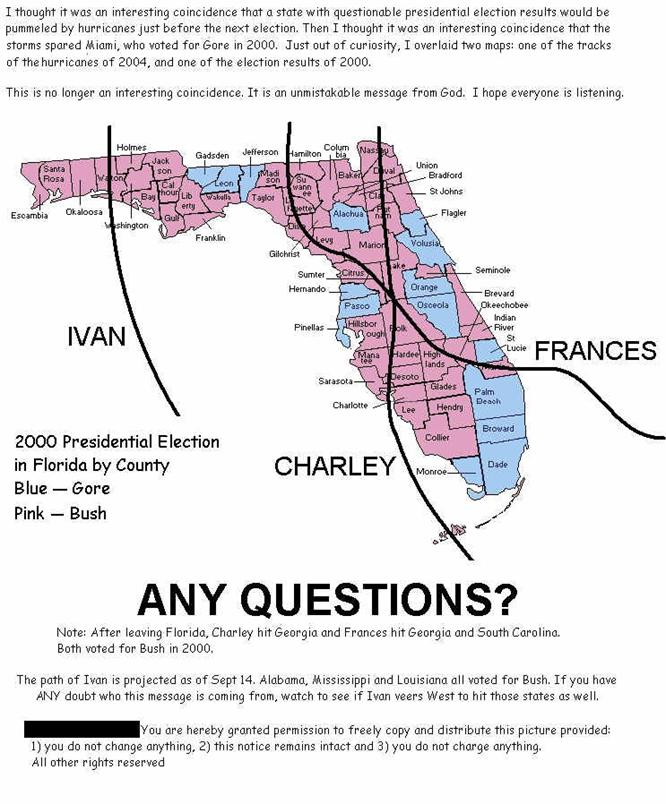
I puzzled over the following map. For long we have suspected that “Acts of God” could be recognized in the catastrophes that God will visit upon this earth. That is until I read this following article. The final One World Government will be controlled by Lucifer himself and is now called by many as the Luciferian World Order. We do know that one of the goals of Lucifer was to be as “though he were God.”
In the search for control, human technology is now technologically developed so that man can control nature or control where the wrath of nature will be visited. We now have one brave nationally recognized weatherman come forth with the evidence that governmental agencies of men now have the ability through Russian Scalar Technology to control the weather as it approaches our nation or any nation on earth.
No single state has been hit by 4 hurricanes in single season since 1886
Serious question: Are Hurricanes: Scalar? – October 3, 2004

TV Weatherman Scott Stevens' Page
The Alpha-Omega Report - I received an incredibly
interesting email from TV weatherman Scott Stevens who folks in the Pacific Northwest may recognize. He's been taking a lot of pictures of anomalous
clouds and sent us the following email (used by permission). This report
was first presented during the last week of September 2004, but Scott followed
up a CD of dozens of photos of "digitized" looking weather - which
are appended following his report...
Take a look - read his report - look at the pictures - and see if everything looks "normal" to you... He's got dozens of pictures that don't look like anything in the textbooks to us.
 Original Report
Thanks for maintaining urban survival… it is one of five sites I have to visit each morning.
I am a meteorologist at an affiliate in the Northwest who now uses scalar weapons signatures within the clouds to better my forecasting record. After closely watching high-resolution visible satellite imagery there is no question in my mind that these storms (4 Hurricanes that hit Florida) weren’t altered and guided to their final destinations. No doubt what so ever. I have come to a further conclusion; that the entire Earth’s weather had been digitized. There is not a flood, thunderstorm, cyclone, or drought that isn’t allowed to happen. Control over global weather is complete.
This way it is much easier to control portions, hurricanes/storms, within this system.
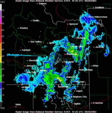
Below is a visible image taken from the NWS/Pocatello, ID page June 7th at 7pm MDT 2004…
Several points of interest:
1) The squall line is cut into segments/digitized.
2) Sharp break toward the SW end of the line
3) Missing square toward the end of that squall line
4) Square cloud over Billings MT
5) Two square clouds, thin ones, over the north end of Yellowstone…
6) Two straight line clouds one run N/S the other E/W above/north in the NW quadrant of this image. Also note a pivot cloud to join the two.
Squares evident again here. A composite of four scan elevations shows a large square with Blackfoot and Pocatello inside the grid
with the orientation tilted ssw/nne. A sun spike radiates nearly due west from the radar dish as this image was captured with the sun angle at 1 degree off the western horizon.
Squares evident again here. A composite of four scan elevations shows a large square with Blackfoot and Pocatello inside the grid
 with the orientation tilted ssw/nne.
A sun spike radiates nearly due west
with the orientation tilted ssw/nne.
A sun spike radiates nearly due west 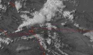 from the radar dish as this image
was captured with the sun angle at 1 degree off the western horizon.
from the radar dish as this image
was captured with the sun angle at 1 degree off the western horizon.
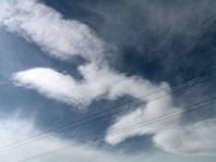
Square clouds like this don't make sense to us, either. Stevens has been taking literally thousands of pictures of clouds that don't seem to behave as they should from a classical meteorology standpoint. His question? Is there some combination of chemtrails and scalar weapons at work to control earth's weather? I'd be willing to bet more than a few people in Florida are wondering the same thing...
No doubt Stevens will take some heat for going public here, and we've careful not to give his station affiliation, but it appears he's doing good basic science: making observations and trying to correlate them with known phenomena. When things don't fit, he's asking the obvious question.
Cutting Edge Newsletter (October 8, 2004) reported on this phenomenon:
“I emailed Scott to ask him if he really wrote this article in Urban Survival, and he emailed back to say, "Yes", he had written that article. In this email, he stated that the scalar energy field is used to control global weather 24/7. He further stated that this control 100% of the time is necessary or "they" would lose control. I have an email into Scott clarifying who the "they" is, but since Lt. Col. Beardon has stated that Russia uses Scalar Weaponry while the United States uses HAARP, we would assume that the "they" using scalar weaponry to control the weather are the Russians. Col. Beardon has stated that the last year in which America has experienced normal weather -- weather not controlled by scalar -- was 1976.”
“Now, look above at this statement again, quoting from the Urban Survival article:
"... the entire Earth’s weather had been digitized. There is not a flood, thunderstorm, cyclone, or drought that isn’t allowed to happen. Control over global weather is complete. This way it is much easier to control portions, hurricanes/storms, within this system."
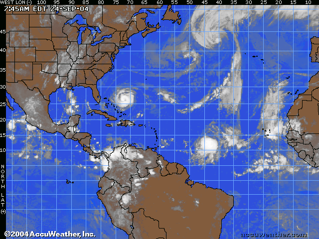
Hurricanes Ivan and Jeanne Tracking across the Atlantic
“Global control over weather has been accomplished by the use of scalar weaponry! This means that Cutting Edge has been correct when we state that hurricanes have been created and steered exactly where the Illuminati wants them to go, undoubtedly to achieve their long-term goal of massive social engineering through the U.N. "Reserve and Corridor System To Protect Biodiversity". (Read NEWS1368, NEWS1862, NEWS1953, NEWS1960)”
“Now, we know the truth, because an NBC weatherman has possessed the courage to tell us. Scalar Weaponry signals are controlling weather globally, with the capability of steering the storms exactly where global authorities wants them to be steered!”
FAIR USE NOTICE

This site contains copyrighted material the use of which has not always been
specifically authorized by the copyright owner. We are making such material
available in our efforts to advance understanding of environmental, political,
human rights, economic, democracy, scientific, and social justice issues, etc.
We believe this constitutes a 'fair use' of any such copyrighted material as
provided for in section 107 of the US Copyright Law. In accordance with Title
17 U.S.C. Section 107, the material on this site is distributed without profit
to those who have expressed a prior interest in receiving the included
information for research and educational purposes. For more information go to: http://www.law.cornell.edu/uscode/17/107.shtml